
Key Takeaways for Space-Based LIDAR and Hyperspectral Imaging
- Technological Advancements: LIDAR offers precise 3D elevation data, while hyperspectral imaging captures detailed spectral bands for material analysis.
- Complementary Insights: The integration of LIDAR’s structural data with hyperspectral imaging’s material identification provides a deeper understanding of environmental and geological processes.
- Commercial Applications: These technologies are increasingly applied in agriculture, mining, forestry, water management, and urban development.
- Future Innovations: AI, machine learning, and quantum sensing are revolutionizing the analysis and interpretation of remote sensing data.
- Challenges and Solutions: Advances in engineering are addressing issues related to sensor limitations, data processing, and environmental resilience in space
Introduction
Space-based LIDAR (Light Detection and Ranging) and hyperspectral imaging are revolutionizing Earth observation. These advanced technologies allow scientists and engineers to measure topography, vegetation structure, water quality, and mineral composition with unprecedented accuracy. When used together, they can provide a multidimensional view of Earth’s surface, structure, and materials. These technologies play a critical role in tackling global challenges such as climate change, disaster response, and sustainable resource management.
What Is Space-Based LIDAR?
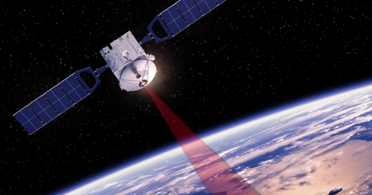
Space-based LIDAR systems emit laser pulses from satellites to measure the distance to Earth’s surface. The time delay of the returning signal provides precise elevation data. Missions like NASA’s GEDI (Global Ecosystem Dynamics Investigation) and ICESat-2 use this technology to map 3D structures of forests, ice sheets, and terrain.Applications of Space-Based LIDAR
Space-based LIDAR has many widely varying applications. A few highlights include:- Forestry and Biomass Estimation: Measures canopy height and vertical structure to support accurate carbon stock assessments and REDD+ programs.
- Topographic Mapping: Produces high-resolution Digital Elevation Models (DEMs) over large, often inaccessible areas.
- Ice Sheet Monitoring: Tracks elevation changes to assess melting rates and their impact on sea level rise.
- Urban Planning: Supports infrastructure design, flood modeling, and structural analysis for smart cities and disaster preparedness. LIDAR supports smart city initiatives by providing high-resolution data for infrastructure optimization, traffic management, and disaster resilience planning.
What Is Hyperspectral Imaging?
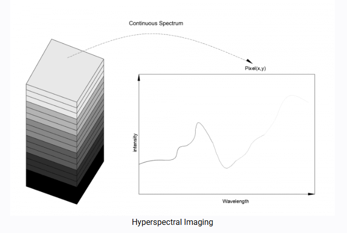
Hyperspectral imaging involves collecting data across hundreds of narrow, contiguous spectral bands. Each pixel in an image contains a full spectral signature, allowing identification of materials based on their reflectance properties. Instruments like NASA’s Hyperion and ESA’s PRISMA deliver this data from orbit, unlocking insights into land, water, and atmospheric phenomena.
Applications of Hyperspectral Imaging
Hyperspectral imaging can be used together with LIDAR or on its own. Some of its applications include:
- Agriculture: Assesses crop health, identifies nutrient deficiencies, and monitors diseases across fields. For instance, hyperspectral imaging has been used to monitor crop health during droughts in California, enabling targeted irrigation strategies.
- Geology and Mining: Detects specific minerals and lithologies for exploration and environmental monitoring.
- Water Quality Monitoring: Tracks sediment loads, algal blooms, and chemical pollutants in rivers, lakes, and oceans. Recent studies have leveraged hyperspectral imaging to track harmful algal blooms in Lake Erie.
- Disaster Response: Maps damage by identifying burned vegetation, flooded zones, and hazardous contamination after natural disasters.
Synergy Between LIDAR and Hyperspectral Imaging
The fusion of LIDAR’s structural data and hyperspectral imaging’s compositional insights enables a more complete understanding of ecosystems and geophysical processes.
What does that mean, in practice? Here are three examples of synergistic applications.
- Wildfire Monitoring: Hyperspectral data detects burn severity and plant regrowth even while LIDAR quantifies changes in forest structure and fuel loads. For instance, the 2023 California wildfires were studied using fused LIDAR and hyperspectral data to assess burn severity and guide reforestation efforts.
- Flood Detection and Management: LIDAR maps floodplain elevation and water extent while hyperspectral imaging evaluates water quality and contamination.
- Habitat and Biodiversity Mapping: LIDAR reveals canopy gaps and terrain variation while hyperspectral data identifies plant stress and species diversity.
Together, these tools support precision conservation, sustainable resource use, and environmental risk mitigation.
Manufacturing Challenges and Solutions
The development and deployment of space-based LIDAR and hyperspectral imaging systems face several key challenges.:
- Miniaturization & Weight Reduction: Space missions require compact, lightweight sensors. Solution: Advanced materials like carbon fiber composites and 3D printing help reduce weight without compromising structural integrity.
- Optical Precision & Calibration: Ensuring high accuracy in sensors demands precise alignment and calibration. Solution: AI-driven calibration and automated alignment improve precision and reduce manual errors.
- Radiation Hardening: Space sensors must withstand high radiation levels. Solution: Radiation-resistant coatings and GaN semiconductor materials enhance durability.
- Power Consumption & Thermal Management: Efficient power use and heat dissipation are critical for long-term operation in space. Solution: Low-power electronics and passive cooling systems improve efficiency.
- Data Processing & Transmission: Hyperspectral imaging generates massive datasets that need quick processing and transmission. Solution: AI-driven data compression and onboard edge computing optimize bandwidth use and processing speed.
Limitations of Space-Based Data
Aside from the challenges above, space-based LIDAR and hyperspectral imaging face several limitations:- Atmospheric Interference: Atmospheric composition can distort measurements, requiring complex correction algorithms.
- Spatial and Temporal Constraints: Predefined satellite orbits result in gaps in data coverage and limited temporal resolution.
- High Cost and Technical Complexity: Developing and launching space-based sensors remains expensive, limiting access to well-funded organizations.
- Data Overload and Processing Challenges: Large datasets from hyperspectral imaging require significant computational power for real-time processing.
- Limited Sensor Lifespan: Harsh space conditions can degrade sensors over time, though emerging self-healing materials may extend their durability.
Future Prospects
The next generation of space-based remote sensing will rely heavily on smarter, more automated platforms. We expect to continue to see advances in:- AI & Machine Learning: Enables rapid feature extraction, anomaly detection, and predictive modeling.
- Quantum Sensing: Offers unprecedented sensitivity for detecting small changes in gravity, light, or magnetic fields. Quantum sensing can detect gravitational anomalies with unprecedented sensitivity, paving the way for advanced geological surveys from space.
- Smaller Satellites (CubeSats): Provide affordable, frequent, and distributed sensing platforms.
- Data Fusion Platforms: Combine LIDAR, hyperspectral, SAR, and multispectral datasets for richer, actionable insights.
Keys to Space-based LIDAR and Hyperspectral Imaging
Space-based LIDAR and hyperspectral imaging are at the forefront of a remote sensing revolution. Their integration, supported by AI, miniaturized satellite platforms, and advanced calibration methods, is transforming how we monitor ecosystems, manage natural resources, and respond to global challenges. To fully realize the potential of these technologies, increased investment in research, international collaboration, and public-private partnerships will be essential in shaping a sustainable future for Earth observation. As technology matures, these systems will become even more essential for understanding—and protecting—our planet and beyond.
Avantier provides optical solutions for space based optical communication and space-based quantum communication. Optimize your space projects with Avantier’s high-performance optical systems. Contact us today to learn more about our capabilities and how we can support your project.
Related Content


GREAT ARTICLE!
Share this article to gain insights from your connections!